On March 17, 2013, six days after the second anniversary of the Great East Japan Earthquake and Tsunami, an annual event will resume after a two-year hiatus. It is reed burning at Watarase-yusuichi, or Watarase retarding basin, an extensive wetland that was recently registered as a Ramsar site, in July 2012, as described below.
Watarase- yusuichi
http://www.ramsar.org/cda/en/ramsar-documents-list-anno-japan/main/ramsar/1-31-218%5E16573_4000_0__
03/07/12; Ibaragi, Tochigi, Gunma, Saitama; 2,861 ha; 36°14'20"N 139°40'56"E. National Wildlife Protection Zone. A natural river flood plain where the Watarase, Uzuma and Omoi rivers meet and includes the Watarase reservoir, an artificial retarding basin surrounded by an embankment managed mainly for flood control. Located 60 km north of Tokyo, it is representative of a Phragmites australis-dominated low moor wetland in the Japanese Evergreen Forest biogeographic ecoregion. The extensive reedbed is one of the largest in the biogeographic region and supports a diversity of wetland flora and fauna. The site has an important flood control function by retarding the flood water from the rivers that flows into the site, and then slowly releasing the water into the Tone River that flows downstream. It is also used for fisheries, recreation, and environmental education. The wetland is at risk of drying up due to excess deposits of earth and sand and is being maintained through excavation since 2010. Ramsar Site no. 2061. Most recent RIS information: 2012.
Aerial view of Watarase-yusuichi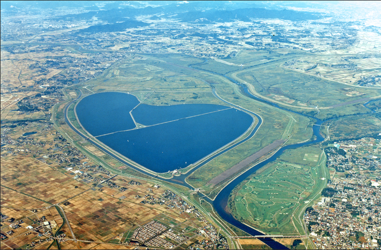
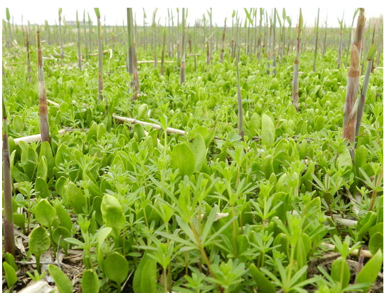
However, the wetland habitat is apparently deteriorating due to the absence of reed burning, leading to poor growth of reed and other rare plants.
Reed burning had always been sponsored by “Federation of Cooperatives Utilizing Watarase-yusuichi,” consisting of representatives from regions which utilize the retarding basin, and co-sponsored by the Liaison Committee of public workers from four cities and two towns in four prefectures, Tochigi, Saitama, Ibaraki and Gunma.
A joint committee consisting of the area local governments and the national government investigated the effect of radiation stemming from reed burning in January, checking the concentration of radioactive cesium in the incinerated ashes of reed and bottom grass. The maximum concentration was 930 Bq/kg, which was much less than 8,000 Bq/kg, the permissible limit for regular radioactive waste that can be safely disposed of in landfill. (This limit was created by the government due to the emergency situation after the accident, and it is by no means a small number). As a result, the joint committee decided on February 1, 2013, that it would be safe to resume reed burning.
As the “Federation of Cooperatives Utilizing Watarase-yusuichi” refused to take any responsibility in case something happened, it was decided that the Liaison Committee would be the sponsor. An effort will be made to the burning area small to avoid the spread of ashes and measuring ambient radiation levels before and after the fire is lit.
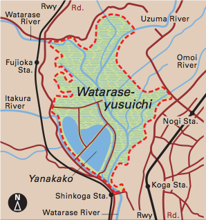
The general location of Watarase-yusuichi (below)
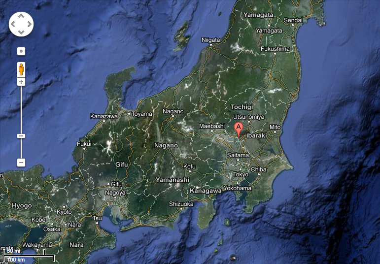
The light green area in the map below shows Watarase-yusuichi.
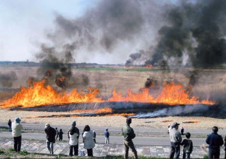
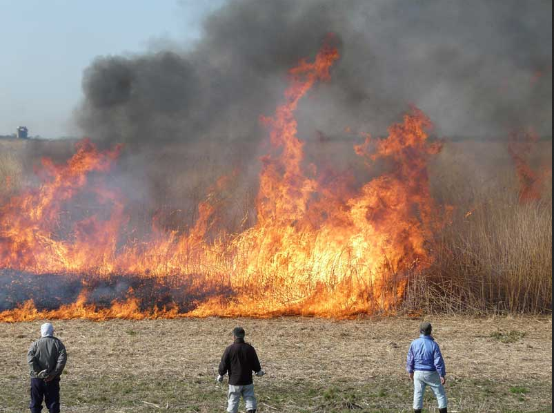
This site shows images of the past reed burning.
http://www.geocities.jp/nekko3rays/d_yoshiyaki.html
This video shows the 2009 reed burning.
http://www.youtube.com/watch?v=_6m9dpFHo3Q
*************************
The black smoke in the above images and the video is rather unsettling and difficult to ignore. In fact, according to the Tokyo Metropolitan Government Environmental Research Institute, field burning produces as much as 10,000μg/m3 of PM2.5 (particulate matter 2.5, which refers to very fine particles with diameter of 2.5 μm), which is of special interest in pollution as it is known to cause detrimental health effects such as respiratory illnesses.
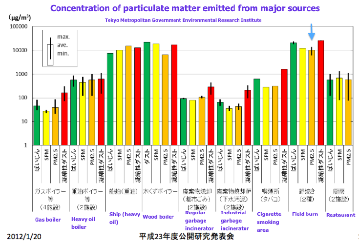
http://www.tokyokankyo.jp/kankyoken_contents/research-meeting/h23-01/2302-pp.pdf
Comparative diagram of PM2.5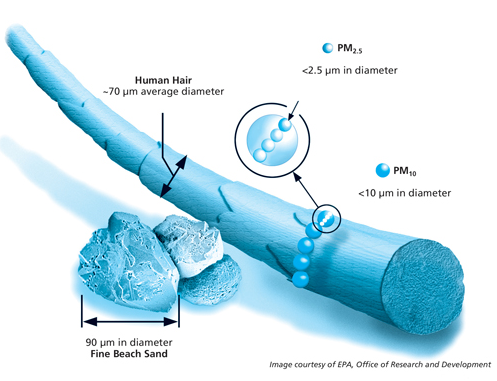
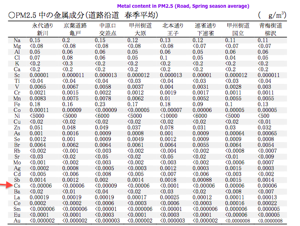
Furthermore, it has been shown that PM2.5 can contain cesium as in the table showing metal contents of PM2.5 collected by roadside in various parts of Tokyo.
http://www.kankyo.metro.tokyo.jp/air/attachement/1-1%20h20%20taikikankyoutyousa%20kekkahoukokusyo(an).pdf
To be clear, there is no testing done to identify radioactive materials in PM2.5. It is only a postulate, but this represents a large gap in data which could be used to inform the world of the dangers of burning radiation contaminated areas.
The cesium in PM2.5 in the above table has no designation as to its radioactive status. Some non-radioactive cesium does exist in nature. The amount shown in this table is very small, but it proves that cesium can exist in PM2.5.
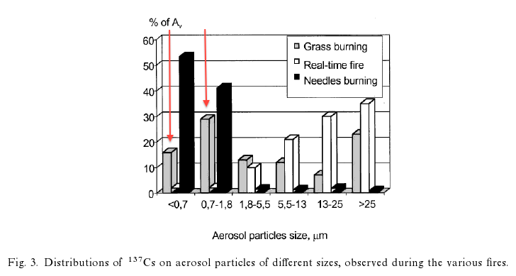
In Chernobyl, wildfires in the contaminated areas have presented problems. In this research study, Vegetation fires, smoke emissions, and dispersion of radionuclides in the chernobyl exclusion zone http://www.treesearch.fs.fed.us/pubs/34263, an experimental grass fire revealed that nearly 45% of Cs137 was in the form of radioactive aerosols smaller than 1.8 μm, well within the PM2.5 range, as depicted by red arrows in the graph shown below.
As it has been in the news, PM2.5 levels in China are skyrocketing lately, some of which has been drifting towards Japan causing severe air pollution. In addition, it has been known that particulate matter from China reaches the United States via the world’s jetstream activity as described in the article below.
China’s Rise Creates Clouds of U.S. Pollution
http://aliciapatterson.org/stories/china%E2%80%99s-rise-creates-clouds-us-pollution
EPA’s PM2.5 site:
http://www.epa.gov/pmdesignations/
In other words, the prospective reed burning could release radioactive material into the air, some of which could be transported to other parts of the world, even in the absence of explosive forces of explosion, as PM2.5.
After the Fukushima nuclear accident, which involved 3 explosions beginning March 13, the radioactivity began to reach the west coast of the United States on March 18th.
On March 17, 2013, the proposed reed burning of the Watarase-yusuichi, has the potential to further spread radioactive materials beyond Japan's borders - affecting other nations. Alternate dates proposed, in case of rain or wet conditions, are March 20 and 24. People of the world need to realize that a strong connection between burning contaminated materials and the release of radioactive elements exists and poses a real threat to both humanity and our ecological support systems.
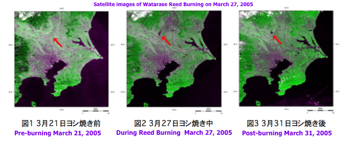
It is such a massive scale of burning that it is identifiable from above the Earth. As seen in the satellite images of the 2005 Reed Burning from the link provided below, the area of the burning can be seen at the tip of the red arrow in the middle image taken during the burning and the right image 4 days after the burning. http://www.eorc.jaxa.jp/imgdata/topics/2005/tp050401.html
Please watch the wind direction on March 17, moiitor the EPA PM2.5 monitoring site, AirNOW, for any changes, and protect yourselves from potentially radioactive dust.
Live camera covering the Watarase-yusuichi area:
Watarase-yusuichi station
http://www.ktr.mlit.go.jp/tonejo/cctv/camview.htm?cam8%3C%3E36.22805555555556%3C%3E139.65944444444446
Furukawa station
http://www.ktr.mlit.go.jp/tonejo/cctv/camview.htm?cam5%3C%3E36.192499999999995%3C%3E139.69583333333333
Otome station
http://www.ktr.mlit.go.jp/tonejo/cctv/camview.htm?cam6%3C%3E36.261944444444445%3C%3E139.74749999999997
Nakasato station
http://www.ktr.mlit.go.jp/tonejo/cctv/camview.htm?cam7%3C%3E36.2925%3C%3E139.73250000000002
Wind Map around Fukushima Daiichi Nuclear Power Plant (Google Maps Markers Version)
http://agora.ex.nii.ac.jp/earthquake/201103-eastjapan/weather/gpv/wind/marker/index.html.en
AirNOW:
http://www.airnow.gov/index.cfm?action=airnow.national&__utma=172919287.1407685150.1358728693.1361856928.1361871811.9&__utmb=172919287.4.8.1361871893696&__utmc=172919287&__utmx=-&__utmz=172919287.1361871811.9.9.utmcsr=google|utmccn=%28organic%29|utmcmd=organic|utmctr=%28not%20provided%29&__utmv=172919287.|1=visitor%20id=1407685150=1&__utmk=118164553
Of course, this reed burning is insane and terrible for local area residents’ health as well as the rest of Japan. Sadly, as we approach the second anniversary of the Fukushima nuclear accident, people’s attention is diverted from real radioactive contamination due to the intentional cover-up of this critical situation by the government and the media. Some even seem to believe everything has been cleaned up at Fukushima Daiichi nuclear power plant. Most local residents do not seem to even mention radiation in their daily conversation. Those who would care and talk about the danger of radiation contamination already moved away from areas surrounding Watarase-yusuichi. The rest of the people either believe the government telling them it’s such a miniscule amount of radiation that it won’t affect their health or they don’t care.
It is very curious that Watarase-yusuichi was designated as a Ramsar site as recently as July 2012, a little over a year after the nuclear accident. Was this coincidental? Nevertheless, it is somewhat understandable that they want to go ahead with reed burning to “keep up with the name,” so to speak, as this would be the first reed burning since the Ramsar site designation. However, it still is not logical to endanger area residents and the rest of the world.
Does the preservation of wetland habitat and endangered plant species take precedence over human health? This presents an ethical dilemma, as it speaks as to whose lives are more precious, humans or plants and wildlife. In addition, the history of Watarase-yusuichi as a retarding basin created to sink toxins derived from Ashio copper mine upstream appears to hold an emotional attachment for local people. They want to create and preserve a beautiful wildlife refugee and a central place for promoting the pride of the region which was so hurt by pollution in the past.
Sadly, now the region was polluted again. This time by radiation.
Watarase- yusuichi
http://www.ramsar.org/cda/en/ramsar-documents-list-anno-japan/main/ramsar/1-31-218%5E16573_4000_0__
03/07/12; Ibaragi, Tochigi, Gunma, Saitama; 2,861 ha; 36°14'20"N 139°40'56"E. National Wildlife Protection Zone. A natural river flood plain where the Watarase, Uzuma and Omoi rivers meet and includes the Watarase reservoir, an artificial retarding basin surrounded by an embankment managed mainly for flood control. Located 60 km north of Tokyo, it is representative of a Phragmites australis-dominated low moor wetland in the Japanese Evergreen Forest biogeographic ecoregion. The extensive reedbed is one of the largest in the biogeographic region and supports a diversity of wetland flora and fauna. The site has an important flood control function by retarding the flood water from the rivers that flows into the site, and then slowly releasing the water into the Tone River that flows downstream. It is also used for fisheries, recreation, and environmental education. The wetland is at risk of drying up due to excess deposits of earth and sand and is being maintained through excavation since 2010. Ramsar Site no. 2061. Most recent RIS information: 2012.
Aerial view of Watarase-yusuichi
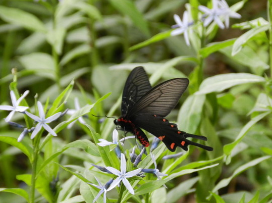
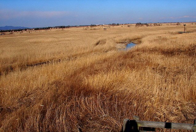
Nature and wildlife at Watarase-yusuichi
Watarase reed burning, annually conducted in mid to late March, was cancelled in 2011 due to difficulties with securing firefighters to prevent burning beyond proscribed areas, after the earthquake, tsunami and nuclear disaster. In 2012, local residents opposed to it after radioactive material was detected in the ash of the bottom grass which underwent test incineration. Four prefectures abutting the Watarase-yusuichi, Tochigi, Saitama, Ibaraki and Gunma are located south of Fukushima prefecture and received consistent radioactive fallout regularly after the nuclear accident.
However, the wetland habitat is apparently deteriorating due to the absence of reed burning, leading to poor growth of reed and other rare plants.
Reed burning had always been sponsored by “Federation of Cooperatives Utilizing Watarase-yusuichi,” consisting of representatives from regions which utilize the retarding basin, and co-sponsored by the Liaison Committee of public workers from four cities and two towns in four prefectures, Tochigi, Saitama, Ibaraki and Gunma.
A joint committee consisting of the area local governments and the national government investigated the effect of radiation stemming from reed burning in January, checking the concentration of radioactive cesium in the incinerated ashes of reed and bottom grass. The maximum concentration was 930 Bq/kg, which was much less than 8,000 Bq/kg, the permissible limit for regular radioactive waste that can be safely disposed of in landfill. (This limit was created by the government due to the emergency situation after the accident, and it is by no means a small number). As a result, the joint committee decided on February 1, 2013, that it would be safe to resume reed burning.
As the “Federation of Cooperatives Utilizing Watarase-yusuichi” refused to take any responsibility in case something happened, it was decided that the Liaison Committee would be the sponsor. An effort will be made to the burning area small to avoid the spread of ashes and measuring ambient radiation levels before and after the fire is lit.
The general location of Watarase-yusuichi (below)
The light green area in the map below shows Watarase-yusuichi.
This site shows images of the past reed burning.
http://www.geocities.jp/nekko3rays/d_yoshiyaki.html
This video shows the 2009 reed burning.
http://www.youtube.com/watch?v=_6m9dpFHo3Q
*************************
The black smoke in the above images and the video is rather unsettling and difficult to ignore. In fact, according to the Tokyo Metropolitan Government Environmental Research Institute, field burning produces as much as 10,000μg/m3 of PM2.5 (particulate matter 2.5, which refers to very fine particles with diameter of 2.5 μm), which is of special interest in pollution as it is known to cause detrimental health effects such as respiratory illnesses.
http://www.tokyokankyo.jp/kankyoken_contents/research-meeting/h23-01/2302-pp.pdf
Comparative diagram of PM2.5
Furthermore, it has been shown that PM2.5 can contain cesium as in the table showing metal contents of PM2.5 collected by roadside in various parts of Tokyo.
http://www.kankyo.metro.tokyo.jp/air/attachement/1-1%20h20%20taikikankyoutyousa%20kekkahoukokusyo(an).pdf
To be clear, there is no testing done to identify radioactive materials in PM2.5. It is only a postulate, but this represents a large gap in data which could be used to inform the world of the dangers of burning radiation contaminated areas.
The cesium in PM2.5 in the above table has no designation as to its radioactive status. Some non-radioactive cesium does exist in nature. The amount shown in this table is very small, but it proves that cesium can exist in PM2.5.
In Chernobyl, wildfires in the contaminated areas have presented problems. In this research study, Vegetation fires, smoke emissions, and dispersion of radionuclides in the chernobyl exclusion zone http://www.treesearch.fs.fed.us/pubs/34263, an experimental grass fire revealed that nearly 45% of Cs137 was in the form of radioactive aerosols smaller than 1.8 μm, well within the PM2.5 range, as depicted by red arrows in the graph shown below.
As it has been in the news, PM2.5 levels in China are skyrocketing lately, some of which has been drifting towards Japan causing severe air pollution. In addition, it has been known that particulate matter from China reaches the United States via the world’s jetstream activity as described in the article below.
China’s Rise Creates Clouds of U.S. Pollution
http://aliciapatterson.org/stories/china%E2%80%99s-rise-creates-clouds-us-pollution
EPA’s PM2.5 site:
http://www.epa.gov/pmdesignations/
In other words, the prospective reed burning could release radioactive material into the air, some of which could be transported to other parts of the world, even in the absence of explosive forces of explosion, as PM2.5.
After the Fukushima nuclear accident, which involved 3 explosions beginning March 13, the radioactivity began to reach the west coast of the United States on March 18th.
On March 17, 2013, the proposed reed burning of the Watarase-yusuichi, has the potential to further spread radioactive materials beyond Japan's borders - affecting other nations. Alternate dates proposed, in case of rain or wet conditions, are March 20 and 24. People of the world need to realize that a strong connection between burning contaminated materials and the release of radioactive elements exists and poses a real threat to both humanity and our ecological support systems.
It is such a massive scale of burning that it is identifiable from above the Earth. As seen in the satellite images of the 2005 Reed Burning from the link provided below, the area of the burning can be seen at the tip of the red arrow in the middle image taken during the burning and the right image 4 days after the burning. http://www.eorc.jaxa.jp/imgdata/topics/2005/tp050401.html
Please watch the wind direction on March 17, moiitor the EPA PM2.5 monitoring site, AirNOW, for any changes, and protect yourselves from potentially radioactive dust.
Live camera covering the Watarase-yusuichi area:
Watarase-yusuichi station
http://www.ktr.mlit.go.jp/tonejo/cctv/camview.htm?cam8%3C%3E36.22805555555556%3C%3E139.65944444444446
Furukawa station
http://www.ktr.mlit.go.jp/tonejo/cctv/camview.htm?cam5%3C%3E36.192499999999995%3C%3E139.69583333333333
Otome station
http://www.ktr.mlit.go.jp/tonejo/cctv/camview.htm?cam6%3C%3E36.261944444444445%3C%3E139.74749999999997
Nakasato station
http://www.ktr.mlit.go.jp/tonejo/cctv/camview.htm?cam7%3C%3E36.2925%3C%3E139.73250000000002
Wind Map around Fukushima Daiichi Nuclear Power Plant (Google Maps Markers Version)
http://agora.ex.nii.ac.jp/earthquake/201103-eastjapan/weather/gpv/wind/marker/index.html.en
AirNOW:
http://www.airnow.gov/index.cfm?action=airnow.national&__utma=172919287.1407685150.1358728693.1361856928.1361871811.9&__utmb=172919287.4.8.1361871893696&__utmc=172919287&__utmx=-&__utmz=172919287.1361871811.9.9.utmcsr=google|utmccn=%28organic%29|utmcmd=organic|utmctr=%28not%20provided%29&__utmv=172919287.|1=visitor%20id=1407685150=1&__utmk=118164553
Of course, this reed burning is insane and terrible for local area residents’ health as well as the rest of Japan. Sadly, as we approach the second anniversary of the Fukushima nuclear accident, people’s attention is diverted from real radioactive contamination due to the intentional cover-up of this critical situation by the government and the media. Some even seem to believe everything has been cleaned up at Fukushima Daiichi nuclear power plant. Most local residents do not seem to even mention radiation in their daily conversation. Those who would care and talk about the danger of radiation contamination already moved away from areas surrounding Watarase-yusuichi. The rest of the people either believe the government telling them it’s such a miniscule amount of radiation that it won’t affect their health or they don’t care.
It is very curious that Watarase-yusuichi was designated as a Ramsar site as recently as July 2012, a little over a year after the nuclear accident. Was this coincidental? Nevertheless, it is somewhat understandable that they want to go ahead with reed burning to “keep up with the name,” so to speak, as this would be the first reed burning since the Ramsar site designation. However, it still is not logical to endanger area residents and the rest of the world.
Does the preservation of wetland habitat and endangered plant species take precedence over human health? This presents an ethical dilemma, as it speaks as to whose lives are more precious, humans or plants and wildlife. In addition, the history of Watarase-yusuichi as a retarding basin created to sink toxins derived from Ashio copper mine upstream appears to hold an emotional attachment for local people. They want to create and preserve a beautiful wildlife refugee and a central place for promoting the pride of the region which was so hurt by pollution in the past.
Sadly, now the region was polluted again. This time by radiation.
No comments:
Post a Comment